Recommended by


All You need to know
Peruvian Geography
Peru is located in the western part of South America between the equator and the Tropic of Capricorn. It covers an area of 1,285,220 km², making it the twentieth largest country on Earth and the third largest in South America. It is bordered to the north by Ecuador and Colombia, to the east by Brazil, to the southeast by Bolivia, to the south by Chile, and to the west by the Pacific Ocean. It has an enormous multiplicity of landscapes due to its geographical conditions, which in turn gives it a great diversity of natural resources. The constitution states that Peru's maritime domain extends up to 200 nautical miles.
GEOLOGY:
The territory of Peru is determined by the South American and Nazca plates, which share a convergent limit of subduction, that is, the Nazca Plate subducts over the South American Plate parallel to the South American west coast, at an average speed of 11cm/year.Product of this subduction was formed towards the Jurassic the Peru-Chile Trench as well as the elevation today known as the Andes Mountains. The erosion of the same has formed to the east a vast plain where before the appearance of the Andes there was a portion of sea; this sedimentary region is the Amazon plain. This same erosive process is the cause of the steepness of the Andes.
Due to tectonic subduction, Peru is a highly seismic country and has regions with significant volcanism, mainly in the south. The Peruvian territory is within the so-called Pacific Ring of Fire.
CLIMATE:
Unlike other equatorial countries, Peru does not have an exclusively tropical climate; the influence of the Andes and the Humboldt Current give the Peruvian territory a great climatic diversity. The coast has moderate temperatures, low rainfall and high humidity, with the exception of its warmer and rainy northern region. In the highlands, rainfall is frequent during the summer, while temperature and humidity decrease with altitude until reaching the icy peaks of the Andes. The jungle is characterized by heavy rainfall and high temperatures, with the exception of its southernmost region, which has cold winters and seasonal rains.
HYDROGRAPHY
Most Peruvian rivers originate in the Andes and drain into one of the three existing river basins. Those that flow into the Pacific Ocean are short, steep and seasonal. The tributaries of the Amazon River are longer, much more abundant and their course is less steep once they leave the highlands. The rivers that flow into Lake Titicaca are generally short and have a high flow. The longest rivers in Peru are the Ucayali, the Marañon, the Putumayo River, the Yavari, the Huallaga, the Urubamba, the Mantaro and the Amazon.
BIOGEOGRAPHY
Peru's rugged relief and particular natural history have made it a megadiverse country, with a great variety of ecosystems and, consequently, of flora and fauna.
Although Peru has traditionally been considered to have three natural regions (the coast, the highlands and the jungle), the truth is that there are 6 different terrestrial biomes, 2 marine biomes and 3 freshwater biomes.
As for the Peruvian sea, two marine currents flowing in opposite directions characterize two different ecosystems. To the north, from latitude 3.2°S to latitude 6°S, the El Niño Current or so-called warm sea zone is present with a temperature ranging between 20°C and 27°C. It invades the El Niño Current and the warm sea current. This invades the Humboldt Current, which characterizes the cold sea zone with temperatures ranging between 12°C and 19°C.
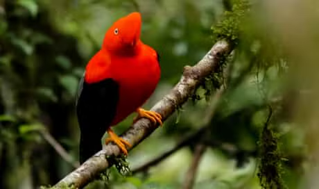
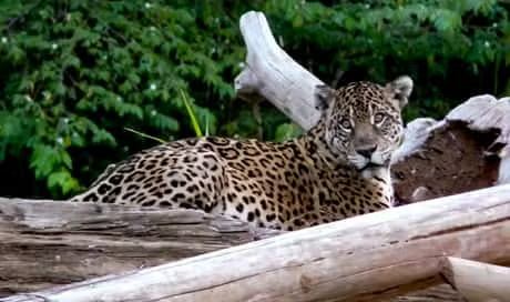
The country's emblematic flora includes the Quina and the Cantuta. The Peruvian fauna is represented by the Vicuña and the cock of the rock.
RELIEVE
The Andes mountain range divides the country into three major physiographic regions: coast, highlands and jungle. The Peruvian coast is a flat desert strip that runs parallel to the coast, reaching a maximum width of 140 km in the Sechura desert. From latitude 6°S to the Chilean border, the Peruvian sector of the Pacific desert is crossed by valleys originated by short seasonal rivers. Along the coast you can find pampas covered with sand that form the country's deserts, such as Sechura (Piura) and Pisco (Ica).
The highlands are made up of a system of mountain ranges. These mountains run in parallel chains: three in the north, three in the center and two in the south. The northern Andes meet the central Andes at the Pasco junction, while the central Andes meet the southern Andes at the Vilcanota junction near Cuzco. The northern Andes are lower and more humid than the average; they include the Porculla pass, which at 2145 m above sea level is the lowest point in the Andean Cordillera. The central Andes are the highest and steepest, and it is here where the highest peak in the country is located, the Huascarán snow-capped mountain, at 6768 m asl. The southern Andes are thicker than those of the north and center. In this sector is the Collao plateau, also known as the altiplano.
The snow-capped Huascarán, in the Andes, is the highest point in Peru and the highest peak in the intertropical zone, as well as the place with the lowest force of gravity on Earth.
The jungle, located to the east, is a vast flat region covered by vegetation. It constitutes almost 60% of the country's surface. There are two distinct regions: high jungle and low jungle. The high jungle is located along the eastern flank of the Andes. Its altitude varies between 800 and 3500 meters above sea level. It covers from the northern border zone to the extreme south of the country. The relief of this area is varied, being the exit of the steep slopes of the Andes and the entrance to the flat and natural region of the jungle.
The low jungle or Amazon rainforest is located between 80 and 800 meters above sea level, in this area are the largest and most navigable rivers such as the Amazon, which passes through the city of Iquitos. The relief is flat and the Contamana mountain range stands out, located on the left bank of the Yavari River. Its highest point reaches 780 meters above sea level.
NATURAL REGIONS
The ancient inhabitants of the Andes possessed significant geographic knowledge about the land they inhabited. This knowledge came about thanks to the interaction they experienced with their environment in the process of producing their means of existence. These men came to identify different ecological levels to which they gave different names. With the arrival of the Spaniards to American territory, the division made by the ancient Andean settlers was replaced by a new one in which the Peruvian territory was divided into three large regions: coast, highlands and jungle.
In the first decades of the 20th century, the existence of different altitudinal regions in the interior of the country was again raised, criticizing the simplistic division given by the Spanish conquerors. Later, thanks to the efforts of different national and foreign scholars such as Pedro Paulet, José de la Riva-Agüero, among others, modern geographical studies on Peru were accumulated. These studies were synthesized and exposed years later in the thesis on the Eight Natural Regions of Peru (1943) postulated by Javier Pulgar Vidal. According to Pulgar Vidal, the natural regions of the country are the following, from west to east: Chala, Yunga, Quechua, Suni, Puna, Janca, Rupa-Rupa and Omagua.
BIODIVERSITY
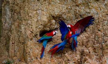
Peru's rugged terrain and particular natural history have caused it to be considered one of the seventeen megadiverse countries, with a great variety of ecosystems and, consequently, of flora and fauna. The country has six different terrestrial biomes, two marine biomes and three freshwater biomes. Along most of the coast is the Pacific desert, while on the north coast and in the inter-Andean valleys of the Marañon River and some tributaries is the equatorial dry forest, a type of ecosystem similar to a tropical savannah that comes from the convergence of Amazonian, Andean and Pacific tropical forest tributaries.
At the mouths of the Tumbes and Piura rivers there are mangrove swamps and up into the Andes there is the montane scrubland biome. According to the World Wildlife Fund, the corresponding ecosystems are the dry puna, the humid puna and the páramo. The most extensive biome in the country (59 % of the territory) and the most biodiverse is located in the east: the Peruvian Amazon rainforest. This is subdivided into low jungle and high jungle. The ecosystems that stand out in this region are cloud forest (north of the departments of Piura and Cajamarca) and a small portion of palm savannah in the far east of the country, in the department of Madre de Dios. As for the Peruvian sea, two marine currents flowing in opposite directions characterize the two ecosystems.
From latitude 6° S to the north, the El Niño current is present, with temperatures ranging between 22°C and 27°C. It collides with the Peruvian or Humboldt current with temperatures ranging between 13°C and 19°C. It collides with the Peruvian or Humboldt current with temperatures ranging between 13°C and 19°C.192 Although both currents provide innumerable resources, it is the Humboldt current that is most important because it has an abundance of plankton and is located in the zone of amplitude of the continental plinth, which favors greater productivity and quantity of marine resources, such as anchoveta and the consequent massive production of fishmeal. The national flower is the cantuta and the most representative tree of the country is the quina tree. As for fauna, the most emblematic species are the Vicuña and the Cock of the Rock.
Peru is one of the twelve biologically richest countries in the world.
8day Manu Park Tour $1,500.00 → $1,450.00
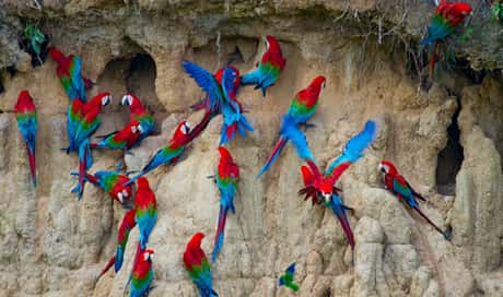
This tour visits the best areas of Manu Park, the Reserved Zone as well as the Cultural Zone with its largest Macaw Clay Lick. This tour also visit a Tapir Clay Lick.
7day Manu Park Tour $1,200.00 → $950.00
6Day Manu Park Tour $1,100.00 → $900.00

5Day Manu Park Tour $1,200.00 → $1,100.00
7day Manu to Pto Maldonado $1,550.00
6day Manu to Pto Maldonado $1,450.00
5day Manu to Pto Maldonado $1,250.00
This our Shortest tour that visits Manu Park by bus and exist through Puerto Maldonado in only 5 hours which allows you to spend longer time exploring the Jungle of Manu Park.
5day Manu Expedition$650.00

4day Manu Expedition $480.00 → $350.00
The shortest tour we have that visits the Cultural Zone of Manu Park. This is an excellent tour for people who don’t have the time to do our longer tours.